79
 Show digital copies
Complete identifier
IKAN, KHR Slg. 1, 79
Map / Plan
Series
Denotation
Denotation
Dränung der Gemarkung Oberbreitzbach
Identification (map / plan)
Title
Title
Bestandsplan 3
Dating
Dating
1966
Original dating
Original dating
Bad Hersfeld, den 11.1.1966
Place
Place
Hohenroda-Oberbreitzbach
Original title
Original title
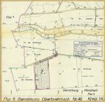
Flur 5 Gemarkung Oberbreitzbach Nr. 46
Description of contents
Description of contents
Die zu dränende Fläche wurde rot umrandet. Straßen/Wege wurden braun und Bäche blau koloriert
Dränabteil 7
Gemarkung Oberbreitzbach Flur 5, Flurstücke 2/1 und 2/2
Further information (map / plan)
Format
Format
43 x 44 cm (H x B)
Scale
Scale
1:2000
Design
Design
Papier, Druck, Koloriert
Number of sheets
Number of sheets
1
Corresponding archival items
Corresponding archival items
IKAN KHR A1.2 Nr. 28
Representations
| Type | Name | Access | Information | Action |
|---|---|---|---|---|
| Original | Plan | 2019 / 21 KHR | Show details page |
