70
 Show digital copies
Complete identifier
IKAN, KHR Slg. 1, 70
Map / Plan
Series
Denotation
Denotation
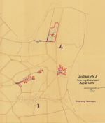
Dränung der Gemarkung Oberstoppel
Identification (map / plan)
Title
Title
Ausbaukarte 9 Gemarkung Unterstoppel
Dating
Dating
1953
Original dating
Original dating
Aufgestellt: Bad Hersfeld, den 15.6.1953
Place
Place
Haunetal-Unterstoppel
Original title
Original title
Ausbaukarte 9
Gemarkung Unterstoppel
Gemarkung Unterstoppel
Description of contents
Description of contents
Die zu dränenden Flächen wurden rot umrandet
Dränabteilungen 19, 20, 21, 22 und 23
Information on manufacturer
Author
Author
[Rein] Kulturb. Ing.
Further information (map / plan)
Format
Format
55 x 50 cm
Design
Design
Papier, Druck, Koloriert
Number of sheets
Number of sheets
1
Corresponding archival items
Corresponding archival items
IKAN KHR A1.2 Nr. 26
Information / Notes
Additional information
Additional information
Blatt 9
Representations
| Type | Name | Access | Information | Action |
|---|---|---|---|---|
| Original | Plan | 2019 / 21 KHR | Show details page |
